Mapas de España Básicos
by Centro Nacional de Información Geográfica - CNIG

Features Mapas de España Básicos
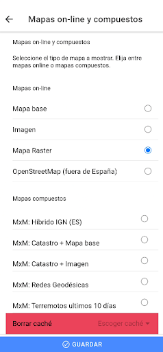
Designed to be very easy to use, without having to carry out any configuration you will be able to connect to the IGN services and the CNIG download center to obtain maps and routes.With this application you will be able to travel the routes of the National Parks or the stages of the Camino de Santiago or use your TRACKS/ROUTES, plan excursions using maps, navigation and guided tours, without the need for an internet connection after downloading data.All the maps and routes used are free and allow you to:- GPS location, even without mobile coverage- Offline maps mode, saved in advance- Draw routes (tracks) with GPS on the maps of the National Geographic Institute.- Save and view the tracks in gpx, kml and kmz format.- Track routes loaded in the application.- Create your points of interest with the possibility of creating your own types of points of interest with associated forms.- Visualization of the positioning by coordinates, course, speed, altitude.
Distance calculation.- Augmented reality service, with important peaks and REGENT vertices.- Access to emergency services, with a link to the AlertCops app, from the Secretary of State for Security.- The application is in Spanish and English.Official Publications Identification Number (NIPO): 162190351
Social Features
Connect and share with friends and the community.
Fitness Tracking
Track your workouts and monitor your health metrics.
Travel Features
Plan and manage your travels with ease.
See the Mapas de España Básicos in Action

Get the App Today
Available for Android 8.0 and above